HISTORY AND GEOGRAPHY
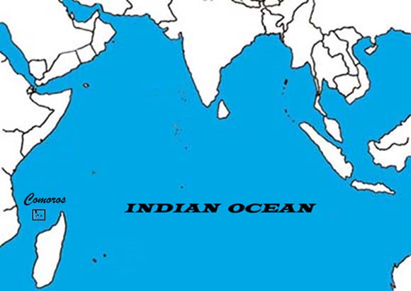
Located in a strategic position at the northern end of the Mozambique Channel, the Comoro Islands once played a major role in a thriving world economy of the western Indian Ocean.
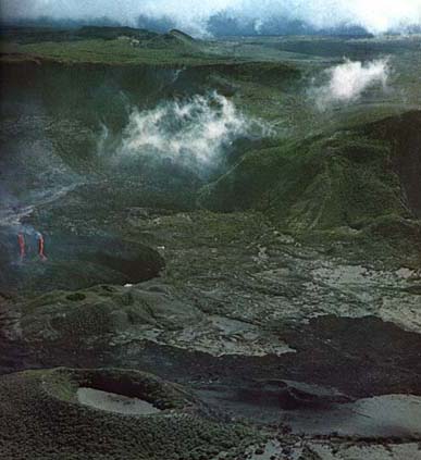
The archipelago arose from the seabed of the western Indian Ocean as the result of volcanic activity.
The four major islands:
 Ngazidja
 Mwali
Mwali
 Nzuwani
 Maoré
Maoré
|
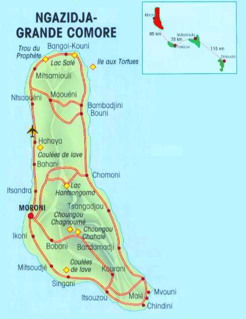
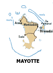
The four major islands: Ngazidja, Mwali, Nzwani, and Mayotte (Maore), are of varying age with distinct topograhical characteristics. Mayotte, the oldest of the islands, is closest to Madagascar and is highly eroded with slow, meandering streams. Ngazidja, the youngest of the islands is closest to Africa and has a massive, active volcano. THE KARTHALA VOLCANO |
 |
 Union
of the Comoros
Union
of the Comoros
The islands became a French colony following the Berlin conference of the 1880s. Three of the islands: Ngazidja, Mwali, and Nzuwani, took independence from France in 1975 and became the Federal Islamic Republic of the Comoro Islands. (This name changed, today the new name is UNION OF THE COMOROS) The fourth major island of the archipelago,
Mayotte (Maore), continues to be administered by France although it
is claimed by the Comoro Republic. This claim has been recognized by
the United Nations General Assembly. In 1997, separatists on Nzwani
and Mwali declared these islands to be independent from the Republic
but this status has not been recognized and is being contested today.
|
Geography
|
The Comoro Islands are an sarchipelago of four islands and several islets located in the western Indian Ocean about ten to twelve degrees south of the Equator and less than 200 miles off the East African coast. They lie approximately halfway between Madagascar and northern Mozambique at the northern end of the Mozambique Channel. The archipelago is the result of volcanic action along a fissure in the seabed running west-northwest to east-southeast. The total area of the four islands is 785 square miles (2,034 square kilometers). |
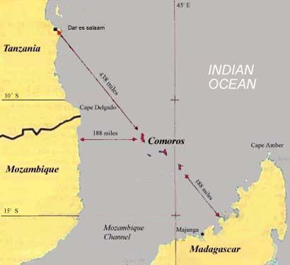 |
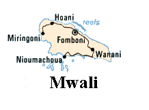
The four major islands are Ngazidja, Mwali, Nzuwani, and Mayotte (Maoré). Ngazidja is the largest and the youngest island in the archipelago. It is the most westerly of the islands, lying 188 miles from Mozambique. Ngazidja has an active volcano that rises to a height of 7,746 feet (2,361 meters) above sea level. Mwali, 28 miles south-southeast of Ngazidja, is the smallest of the islands with a central mountain range that rises 2,556 feet (790 meters) above sea level. Nzuwani lies about twenty-five miles easterly of Mwali, has a central peak that rises 5,072 feet (1,575 meters) above sea level. It also has several swift running streams that cascade down to long, sandy beaches. Forty-four miles to the southeast of Nzwani is Mayotte (Maore), the oldest of the islands. It is almost surrounded by a barrier reef and is fairly flat with slow meandering streams and mangrove swamps.
The names of the islands
and of the capital city in the Comoros, Moroni, has raised interest
among members of The Church of Jesus Christ of Latter-day Saints. In
the Book of Mormon there is reference to the angel Moroni, son of Mormon,
and to the hill, Cumorah. They play central roles in the Book of Mormon
and there is some question about the possible relationship between these
names in the Book of Mormon and those in the Indian Ocean. Mwali is the smallest
of the islands in the Comoro archipelago. Referred to by the French
as Moheli, it has an area of 81 square miles (211 square kilometers).
The island has rich soil, magnificent forests and fine pasture lands.
The valleys and slopes of the island are covered with coconut trees,
coffee trees, cacao and ylang-ylang trees, and a wide variety of crops.
Three small islets on the south side of the island near the harbor of
Nioumachoua provide a natural sheltering place for sailing ships during
inclement weather. In the past, one of these islands--Shisiwa Unefu--was
used as a leper colony. With a population of approximately 30,000, Mwali
is the least densely populated (370 inhabitants per square mile) of
the four islands. In September 1997, a group of secessionists declared
the island independent of the Comoro Republic but this claim has been
rejected by the Republic. |
CLIMATE
| Located a little
more than 10 degrees below the equator in the western Indian Ocean the
islands have a maritime tropical climate. In the wet season from October to April, the predominant northerly winds of the Indian Ocean bring moist, warm air to the region. Heaviest rainfall occurs during the period from December to April and amounts can reach as high as 15 inches (390 mm) in a month. The mean temperature during the wet season is in the high seventies with the hottest month, March, averaging temperatures in the middle eighties (fahrenheit). From May to September southerly winds dominate the region. These are cooler and drier and temperatures in the islands average around 66 degrees fahrenheit (19 degrees celsius). Rainfall and temperature vary from island to island during any month and even vary on an island due to the topography. The central, higher areas of an island are often cooler and more moist than the coastal regions. This variation results in microecologies on the islands with distinct flora and fauna. |
POPULATION
| The
total population of the Comoro Islands is estimated to be over 600,000
people today. Over 27% live in urban areas. A 1980 estimate of the average
density was 182.5 persons per square kilometer, varying between 65.5 persons
per square kilometer in Mwali and 349.1 persons per square kilometer in
Nzwani. Today the densities are much higher. In recent decades the population was increased by the forced evacuation of Comorians from Madagascar and Zanzibar. These peoples resettled in the Comoros adding to an already difficult situation. Earlier, changes in politics in the area had reduced the opportunities for Comorian men to go abroad; one means that had effectively eased population pressures. There still are a number of Comorians living abroad. Comorians can be found living in many parts of the world but most of the emigrants are in Europe or in Kenya and Zanzibar along the East African coast. There are an estimated 60,000 Comorians or people of Comorian descent living in France today. The present population increase is an estimated 3.5% per year with an annual birth rate of 47 births per 1,000 and an annual death rate of 12 deaths per 1,000 population. The most recent estimate of the total fertility rate is 6.8 children born per woman. Life expectancy at birth is 54 years for males and 59 years for females. The inhabitants are a blend of various peoples of the Indian Ocean littoral. African, Malagasy, and Arabic features are clearly evident. Maritime commerce before entry of Europeans into the Indian Ocean brought Comorians into contact with peoples from southern Africa to southeast Asia. Since the end of the fifteenth century European influence has also impacted upon Comorian life. |
LANGUAGE
|
The official languages of The
Union of the Comoro Islands are French and Arabic. French
is the language of government while Arabic is the language of Islam,
the major religion in the Republic. French is used as the official language
on the island of Mayotte. In daily life, most people speak one or more varieties of Comorian, the language group indigenous to the Islands. It is closely related to the Swahili of the East African coast. Comorian is typical of a Bantu language with a large number of noun classes and an elaborate set of verb tenses and aspects. For centuries, people have used Arabic script to write Comorian and there is an attempt presently to normalize an orthography for writing the varieties of the language in Roman script. The rich vocabulary of Comorian has been enhanced by the borrowing of words from many other languages. Since Comorians have been involved in maritime trade for a thousand years or more, they have come into contact with a number of different peoples and their language reflects this contact. Words of Indian, Persian, Arabic, Portuguese, English, and French origin have been added to those of African ancestry. There are four varieties of Comorian spoken in the Islands: Shingazidja, Shimwali, Shinzuwani, and Shimaore, each one named for the primary island on which it is spoken. |